Verren: Difference between revisions
Cabulus104 (talk | contribs) |
Cabulus104 (talk | contribs) No edit summary |
||
| Line 9: | Line 9: | ||
In southeast verren, there is mainly inhospitable desert and steppe near the Suldin Strait. West of that, there is the fertile Cega basin and some more steppe and desert along the coast. A large endorrheic basin lies between Verren's two mountain ranges, mainly made of wetlands. Inner Verren is mainly low-lying plains and forests. Further north lies steppes and taigas, and to the far north there are tundras as well. Population density is higher around the coasts of the Southern Half of Verren. | In southeast verren, there is mainly inhospitable desert and steppe near the Suldin Strait. West of that, there is the fertile Cega basin and some more steppe and desert along the coast. A large endorrheic basin lies between Verren's two mountain ranges, mainly made of wetlands. Inner Verren is mainly low-lying plains and forests. Further north lies steppes and taigas, and to the far north there are tundras as well. Population density is higher around the coasts of the Southern Half of Verren. | ||
Outer Verren and Suldin were formerly one continent until about | Outer Verren and Suldin were formerly one continent until about 4000 BC before Dawn of Nations when the strait flooded, while Inner Verren collided around 15MYA. | ||
== Nations == | == Nations == | ||
Latest revision as of 07:48, 20 March 2025
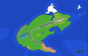
Verren is a continent located within the Northern Hemisphere bordering the Trinitarian Ocean to the east, the Axalifan Ocean and Suldin Strait to the south, and the Outer Ocean to the west. The continent comprises the two halves of Outer Verren and Inner Verren (also known as the Great Lowlands)

Geography
Verren is a very tectonically active continent, lying along two plate boundaries. This causes Verren to have two of the tallest mountain ranges in the world, the Transverric Mountains and the Andes-type mountains in Western Verren (Still working on a name). In contrast, where the highlands end, Verren has mainly flat terrain, especially in Inner Verren and the Verric Wetlands.
In southeast verren, there is mainly inhospitable desert and steppe near the Suldin Strait. West of that, there is the fertile Cega basin and some more steppe and desert along the coast. A large endorrheic basin lies between Verren's two mountain ranges, mainly made of wetlands. Inner Verren is mainly low-lying plains and forests. Further north lies steppes and taigas, and to the far north there are tundras as well. Population density is higher around the coasts of the Southern Half of Verren.
Outer Verren and Suldin were formerly one continent until about 4000 BC before Dawn of Nations when the strait flooded, while Inner Verren collided around 15MYA.